
Upland Side Trail Story
The Upland Side Trail – located on the Riverside Woods Nature Reserve – is ideal for an easy walk. The Upland Side Trail leaves the Goodyear Memorial Side Trail just east of the 1st Line parking lot and remains on the high ground for its 1.2 km length. Take advantage of the bench at the viewpoint, an outlook that is not to be missed with its sweeping view of the far countryside to the north & east.
The Bruce Trail Conservancy purchased this land from Scouts Canada in 2023. Evidence of the popular Scouts camp – picnic tables, etc, remains in several locations on the property. Both parties to the purchase and sale were heartened that the Bruce Trail Conservancy would be preserving nature on this site. In fact, since the purchase, the Conservancy has started to return some of the field portions of the property, adjacent to the Upland Side Trail, to native grassland.
Looking back in time, Indigenous Peoples inhabited and travelled along this area for centuries.
Following the War of 1812, Upper Canada sought to secure more land to settle British immigrants as the number of settlers grew significantly from 95,000 in 1814, to over 186,000 in 1828. The settlers were clearing the land for agriculture.
During this time, the Indigenous Peoples, including the Chippewa, experienced hardship suffering infectious diseases, colonization of hunting and fishing grounds, and increasing colonial policies and practices, particularly after the War of 1812 and after Canadian Confederation in 1867.
In October 1818 the four Chiefs of the Chippewa (Ojibway) nation – “Musquakie, or Yellow Head, Chief of Rein Deer Tribe, Kaqueticum, Chief of the Cat Fish Tribe, Maskigonce of the Otter Tribe, and Manitonobe of the Pike Tribe” – signed Treaty # 18 with William Claus, Superintendent General of Indian Affairs, selling 1,592,000 acres of land to the Crown, covering an area extending from the shore of Nottawasaga Bay (part of Georgian Bay) south to approximately Orangeville. When negotiating Treaty 18, Chief Musquakie requested that the colonial government provide them with a doctor. None was guaranteed in the treaty text.
The land that the Upland Side Trail traverses was settled by the Dodds and Foster families. The eastern portion of the trail is on land that extends to the 2nd Line where James Dodds built a two-storey stone house in 1857 – 10 years prior to Canadian confederation! Carved into the date stone above the front door are the words: “Erected AD 1857 by James Dodds”. (On private land, the house is still standing and has a historical designation.) James’s wife was Mary Foster and her family originally farmed the land that carries the western portion of the Upland Side Trail.
James and his 3 brothers worked on the Welland Canal to achieve their start in Canada and two of his brothers also settled in Mono – Robert Dodds nearby on the lot immediately south of James, George farming about 2 miles to the north-east in Mono. It was not unusual that immigrant families settled close to relatives and friends from their home country (in this case, Ireland). Mutual support aided survival and the possibility of prosperity in a new country.
As you walk the Upland Side Trail you will note that the land slopes off steeply to the north – evidence of the Nottawasaga River valley – a key geographical feature of Riverside Woods.
If you wish, you can make it a 3.2 km loop hike, including the Goodyear Memorial Side Trail and option to add on the 210 metre Rushing River Side Trail down to the Nottawasaga River. These trails cover the descent & ascent through the Nottawasaga River Valley so be prepared for more ups & downs, as compared to the Upland Side Trail which largely remains on flat land.
Enjoy your time under the pine trees and in the meadows on the Upland Side Trail and cast your thoughts back to the many peoples who traversed this land over the centuries and to the Bruce Trail Conservancy that is preserving a ribbon of wilderness, for everyone, forever.
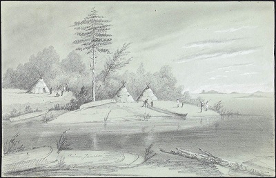
An 1837 sketch of the encampment on Lake Huron of Chief Yellowhead, one of the signatories to Treaty 18. (Library and Archives Canada)